


Early New World Maps
June 14, 2014
The persistent academic argument concerning early voyages to the New World ends with an examination of the cartographic evidence. Maps that have been preserved in the collections of such distinguished archives as the Louvre (in Paris), the British Museum, and the Library of Congress are sufficient to prove that ancient seafarers as far back as the Roman Empire engaged in regular voyages to Ancient America.
The beauty of the ancient maps is that they contain precise details called “Diagnostic Geographical Markers.” These “markers” serve the same function as fingerprints found at a crime scene. These cartographical fingerprints contain unmistakable coastlines, geographical positions on the globe, references of longitude and latitude, proximities to identifiable mainland or islands, place names of cities or territorial titles (also called toponyms), and [amazon asin=0557231655&template=*lrc ad (left)]often text that identifies key features of topography, climate, vegetation, or native species of animals. Historical perspectives provided by the sequence of maps from a particular region are often sufficient to delineate sequential modifications of coastlines as subsequent explorers gradually improved the cartographical knowledge of a particular area.
The importance of examining the cartographical evidence is the realization that all the world’s maritime adventurers and merchants were actively engaged in exploring the world and taking advantage of valuable commodities from the earliest times that ships were capable of ocean sailing. Archaic academic notions that the New World was somehow isolated from Old World contact until after Columbus sailed across the Atlantic in an effort to reach China in the 15th century are based on a Eurocentric religious doctrine that was inherited from the Middle Ages. Most historians got their training at Medieval Church universities; and it was the belief of learned elders in these institutions that the sole purpose for having a Chronicle of the Ages (that is, “history”) was to document the spread of the “One True Religion” around the globe. Modern scholars would do well to abandon this myopic mental[amazon asin=0934666555&template=*lrc ad (right)] baggage, because the survival and prosperity of our species depends upon making an accurate appraisal of where we have come from in the past and where we need to be heading in the future. All the world’s peoples (and all religions) played a role in the past; and together we must build the pathway into the future.
Incremental migrations across lakes and calm coastal regions were taking place by nomads using logs or rafts by a million years BC. These “Stone Age People” traveled between Africa and Asia. By 50,000 BC, the aboriginal peoples of Indonesia sailed rafts to Australia; and maritime hunters from Siberia paddled or sailed dugout canoes along the coastal isles of Alaska, California, and Mexico. Some brazen hunters reached South America by 30,000 BC. By about 4000 BC, civilized peoples in Sumer, India, and China had developed watercraft suitable for roundtrip voyaging. It is at this point in the human story that the notion of “continental isolation” quickly evaporates.
Indo-Sumerian and Chinese legends about transoceanic voyaging date back as far as 3000 BC. Domesticated plants were carried across the seas. New World maize (or “Indian corn”) shows up in the archeological record of Egypt dating as far back in time as 3000 BC. It can be identified on ceramic pots from the Naquada Phase of pastoral villages at campsites along the Nile River. By 1500 BC, the New World plant was featured on temple murals at Deir al-Bahri near Thebes.

Maize or Indian corn at Temple of Pharaoh Hatshepsut, Deir al-Bahri, 1470 BC
Howard Carter’s illustration of Grain from Punt, Egypt Exploration Soc., c. 1900

For additional examples of New World maize in Egypt, Mesopotamia, India, and literary as well as Internet sources see: Gunnar Thompson, Ancient Egyptian Maize, Misty Isles Press/Lulu.com (2010). Scholars from the Egyptian academic community suggest that these maize-like plants actually represent “lettuce.” The Land of Punt was described as the Abode of the Sun that was situated west across the Great Ocean.
Phoenician & Greek Maps of the World
[amazon asin=1601632045&template=*lrc ad (left)]Legends from Classical Greco-Roman featured the ancient Cronus People who, it was said, “measured the earth.” Presumably, they made a map of the world that was based on measurements of longitudes and latitudes at ports all across the globe. The inheritors of the ancient world map were Phoenician mariners who served as the principal carriers of transoceanic commerce from 1000 BC to about 200 BC. Roman victory at the culmination of the Punic Wars in 146 BC ended Phoenician dominance of trade on the Mediterranean Sea and across the Atlantic Ocean to Mexico. Survivors of this conflict fled to the Eastern Seaboards of North America, Mexico, and South America.
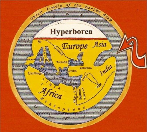
Hecataeus World Map (c.500 BC) portrays the “Old World” (Europe, Africa, and Asia) surrounded by water. Experienced sailors believed there was mainland beyond the ocean; however few mariners traveled beyond the major regions of commerce that are included on this map. The Western Caspian Sea (arrow) is indicated as a huge gulf that opens onto the ocean. This is an early representation of the Gulf of Mexico – where merchants obtained pineapples, corn, turkeys, pumpkins, chili peppers, gold, dyewood, tobacco, and other drugs. They brought in exchange iron tools, hemp rope, wine, oil, and textiles. Hyperboreawas “the Land beyond the North Wind.” This included Labrador, Newfoundland, Nova Scotia, and the Eastern Seaboard of North America.
 New World Natives were dependent upon Phoenician merchants for iron and bronze tools. Top panel includes Phoenician bronze chisels; bottom panel features bronze tools from ancient Peru. Similar chopping tools (called adzes) used the same kinds of bronze blades in regions such as Egypt and Greece that obtained tools from Phoenicians as did the ancient natives of Mexico and Peru (bottom panels).


Eratosthenes’ Map extended the land-mass of Asia towards the east in about 194 BC. It also moved the Caspian Sea up to the Hyperborean (Northern) region; and it added the Red Sea east of Africa and the Arabian Sea. The lower continent – Alter Orbis (or “New World”) was intended to represent South America (arrow). Phoenician mariners and most educated people (which wasn’t very many) realized that earth was round. This knowledge wasn’t important for most people who were ordinary farmers. Modern historians have wrongly assumed that the so-called “Fourth Continent” was added simply to balance the globe. On the contrary, many Phoenicians and Greeks sailed to the overseas land below the equator. It is quite possible that geographers who plied their trade in Greece assumed that the southern continents of Australia and South America were joined together.
[amazon asin=0615814824&template=*lrc ad (left)]
[amazon asin=0615491383&template=*lrc ad (left)]
[amazon asin=0878393129&template=*lrc ad (left)]
[amazon asin=1591431719&template=*lrc ad (left)]
Copyright © 2014 Ancient America
 10 Lucrative Products