


Laser Scans Reveal 60,000 Previously Unknown Maya Structures Hidden in the Central American Jungle!
February 3, 2018
In a monumental archaeological discovery, whose magnitude hasn’t been seen in decades, an aerial survey over northern Guatemala revealed tens of thousands of Maya structures, including pyramids, palaces, temples, fortifications, highways, houses, and farms, which had been hidden for centuries amidst the thick vegetation of the Guatemalan jungle. This incredible discovery indicates that the Mayas had an enormous, interconnected network of ancient cities, which may have been home to as many as 10 to 15 million people some 1,200 years ago.
Archaeologists are Hitting the Ground Running
National Geographic exclusively revealed that the previously unknown ancient structures were spotted using LiDAR (“Light Detection and Ranging”) technology, which can ‘see through’ the jungle canopy to identify monuments below. The aerial scanning technique is revolutionizing the field of archaeology as it quickly reveals man-made sites, which would be near impossible to discover through ground searches due to the dense vegetation and harsh conditions of the jungles of Central and South America.
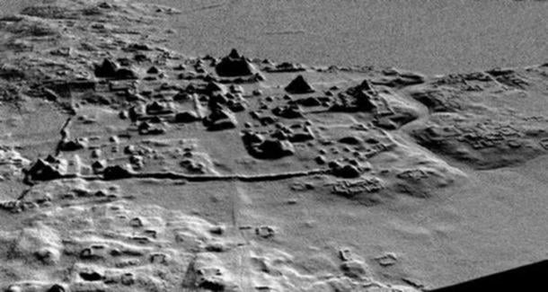
An earlier LIDAR scan that revealed a network of roads, canals, corrals, pyramids, and terraces at El Mirador. Credit: Archaeological Project Cuenca Mirador.
“LiDAR is revolutionizing archaeology the way the Hubble Space Telescope revolutionized astronomy,” said Francisco Estrada-Belli, a Tulane University archaeologist and National Geographic Explorer [via National Geographic]. “We’ll need 100 years to go through all [the data] and really understand what we’re seeing.”
Now that the location of tens of thousands of monuments have been identified, archaeologists are hitting the ground running to begin excavations and explorations of some of the sites.
Enormous ‘Megalopolis’ Revealed
 Amazon.com Gift Card i...
Buy New $15.00
(as of 12:45 UTC - Details)
Amazon.com Gift Card i...
Buy New $15.00
(as of 12:45 UTC - Details)

The project mapped a 2,100 square kilometre (800 square mile) area around the popular tourist site of Tikal in the Petén region of Guatemala. The results of the aerial survey, which produced a series of 3D images of the landscape below the jungle canopy, revealed an enormous network of cities, which is being hailed as a ‘megalopolis’.
The images showed as many as 60,000 previously unknown structures, including complex agricultural systems with canals, dikes, and reservoirs for irrigation, and terracing for supporting food production for the masses. Also discovered was a huge highway network – raised to prevent flooding issues in the rainy season – which connected the cities and quarries, and had been constructed by hand, without the use of the wheel or ‘beasts of burden’.
The interconnected network of ancient Maya cities was home to millions more people than previously thought https://t.co/0E0FafOyRR
— National Geographic (@NatGeo) February 1, 2018
Another surprising finding was the sheer scale of the defensive structures, including walls, ramparts, terraces and fortresses, which indicate that warfare was happening on a much larger-scale than previously realized.
Copyright © 2018 Ancient Origins
 Can the Impending Collapse of Russiagate